
Resilient Northeastern New Jersey held a virtual meeting yesterday explaining their regional partnership to cope with increased flooding due to climate change.
By Daniel Ulloa/Hudson County View
The effort is a joint effort between the New Jersey Department of Environmental Protection (NJDEP), Jersey City, Bayonne, Hoboken, Newark, the Ironbound Community Corporation, the Hudson County government, and the HOPES Community Action Partnership to cope with flooding.
Project Manager Carly Foster, of the consulting firm Arcadis, noted that the NJDEP funds the group’s work and they develop a plan to address flooding. There will be meeting again in October for them to gather input and he final plan is expected to be released in May.
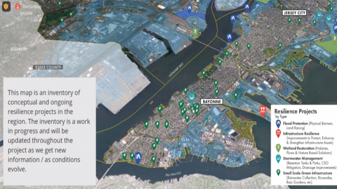
Senior Resilience Planner Mary Kimball, also of Arcadis, said they have different solutions to address flooding from policy and governance and individual community-based actions including modifying inland waterways, restabilizing the shoreline, and stormwater management, barriers, and relocation or setting back from high flood risk areas.
She noted Hoboken has published resiliency guidelines, and Jersey City has a flood overlay zone to ensure certain buildings can withstand flooding.
Kimball noted that the region is very urban with minimal open space, making it more difficult to build flood prevention infrastructure.
From there, Hudson County Division of Planning Principal Planner Kevin Force explained the nature of Hurricane Sandy looming as a threat, but also noted summer storms had caused flooding issues.
Foster also remarked that there has been a lot of flooding in Hoboken and showed pictures of water up to the wheels of a car.
Moriah Kinberg, of NJ Future, said one of the recent rain storms saw flooding on her block on Palisade Avenue in the Jersey City Heights, where cars were also having difficulty on the corner of Webster and Congress Streets.
“I’ve never had that ever on our specific block,” she said.
“We’re going to be looking at tidal flooding from storm surge and also from rainfall events,” Foster said.
She explained they seek to establish working relationships between local governments to cope with flooding in the future, prompting Kinberg to note that New York City uses sensors to track flooding in certain areas.
“We really want to utilize as specific information as we can,” Force said, noting they prefer personal reports to the use of censors.
Areas most impacted are those around the waterways, including parts of Jersey City on the New York Bay and Bayonne’s west side on the Newark Bay. The most vulnerable areas often receive both rain and tidal flooding.
Force explained they are working to ensure redevelopment projects are environmentally sustainable.
The northwestern and southern parts of Hoboken, Jersey City, around Liberty State Park (LSP), Lincoln Park, the Morris Canal area, and Bayfront are being redeveloped sustainably. Wetlands are being restored in Lincoln Park and LSP to better cope with flooding.
“Some of our major assets are the ports and the airport, [they’re] susceptible to flooding. They’re definitely a key player.”
Towards the end of the session, Allen Kratz, a Hoboken resident and the principal of Resilience Works, LLC, asked how American Rescue Plan funds would be utilized, to which he was told all opportunities are being explored right now.


